Below is a copy of Charnwood Borough Planning Department’s Outline Application
Grant Conditionally
Charnwood Borough Council
Development Management, Southfield Road,
Loughborough, Leicestershire, LE11 2TN
| Details of Application | |
| APPLICATION NO: | P/20/2044/2 |
| PROPOSAL: | Outline application for the erection of 45 new dwellings, all matters reserved except access (revised scheme, P/18/0081/2 refers). |
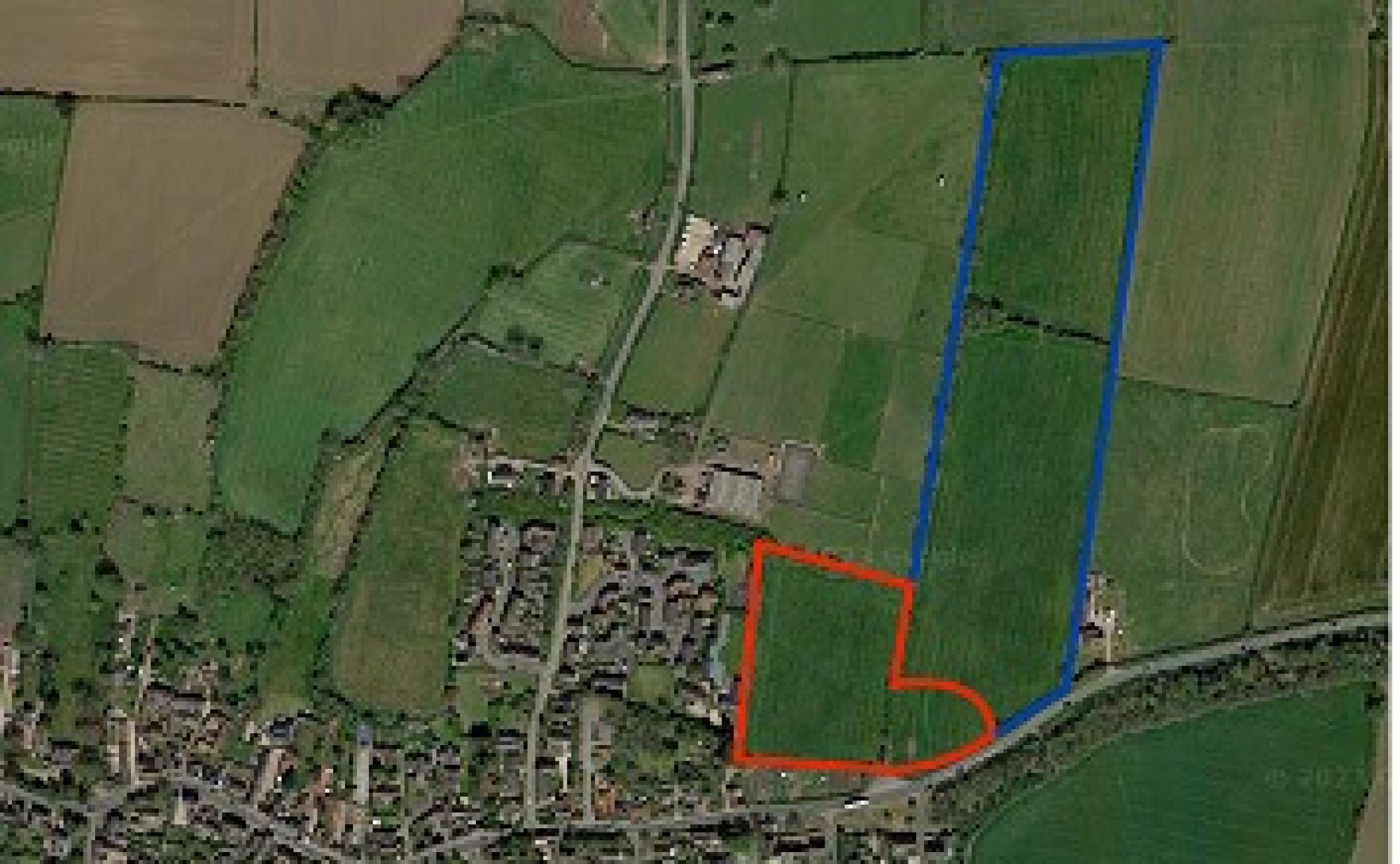
| LOCATION: | Land off East Road, Wymeswold, Leicestershire |
| Details of Decision | Please Read All the Information in this Decision Notice. |
Charnwood Borough Council has considered this application under the Town and Country Planning Act, 1990, and grants permission for the development described in the submitted documents and on any accompanying plans and drawings.
This permission is granted subject to the following Conditions and Reasons why they have been imposed:-
| 1. | Application for approval of reserved matters shall be made within 3 years of the date of this permission and the development shall be begun not later than 2 years from the final approval of the last of the reserved matters.
REASON: To comply with the requirements of Section 92 of the Town and Country Planning Act 1990, as amended by Section 51 of the Planning and Compulsory Purchase Act 2004. |
| 2. | No development shall commence until details of the appearance, landscaping, layout and scale, (“the reserved matters”), have been approved in writing by the local planning authority. The development shall be carried out in accordance with these approved details.
REASON: To accord with the provisions of Section 91 of the Town and Country Planning Act 1990 as amended by the Planning and Compulsory Purchase Act 2004. |
| 3. | The development, hereby permitted, shall be carried out in accordance with the following approved plans:-
P14-299-202 Rev F – Site Access |
| 4. | The reserved matters shall comprise a mix of market and affordable homes that has regard to both identified housing need for the borough and the character of the area and includes an appropriate level of smaller 2/3 bedroom units and single storey units.
REASON: To ensure that an appropriate mix of homes is provided that meets the Council’s identified need profile in order to ensure that the proposal complies with Development Plan policies CS3, and the advice within the NPPF. |
| 5. | No development shall take place until a programme of archaeological work, including the ridge and furrow landscape, which includes a written scheme of investigation has been submitted to and approved in writing by the Local planning authority. The scheme shall include an assessment of significance and research questions; and:-
· The programme and methodology of site investigation and method · The programme for post investigation assessment · Provision to be made for analysis of the site investigation and recording · Provision to be made for the publication and dissemination of the analysis and records of the site investigation · Provision to be made for archive deposition of the analysis and records of the site investigation · Nomination of a competent person or persons/organisation to undertake the works set out within the Written Scheme of Investigation. All works including site clearance shall be carried out in accordance with the Written Scheme of Investigation. REASON: To make sure that any heritage assets are appropriately recorded and/or protected to allow compliance with policies CS14 of the Development Plan and the advice within the NPPF. |
| 6. | The landscaping details submitted pursuant to condition 2 above shall include:-
i) the treatment proposed for all ground surfaces, including hard surfaced areas; ii) planting schedules across the site, noting the species, sizes, numbers and densities of plants and trees; including tree planting within the planting belt to the east of the site; iii) finished levels or contours within any landscaped areas; iv) any structures to be erected or constructed within any landscaped areas including play equipment, street furniture and means of enclosure. v) functional services above and below ground within landscaped areas; and vi) all existing trees, hedges and other landscape features, indicating clearly any to be removed. REASON: To make sure that a satisfactory landscaping scheme for the development is provided so that it integrates into the landscape and surrounding area and complies with policies CS2, CS11 and WV1 of the Development Plan. |
| 7. | The details submitted pursuant to condition 2 above shall include full details of existing and proposed ground levels and finished floor levels of all buildings relative to the proposed ground levels.
REASON: To make sure that the development is carried out in a way which is in character with its surroundings and ensure compliance with policies CS2 and of the Development Plan and associated national and local guidance. |
| 8. | The details submitted pursuant to condition 2 above shall include the following minimum amounts and typologies of open space:-
An 0.04ha on-site multi-function green space REASON: To ensure that the open space needs of future residents are met at a level that complies with Development Plan Policy CS15 |
| 9. | No part of the development shall be occupied until such time as the offsite works shown on Rodgers Leask drawing number P14-299 202 have been implemented in full.
REASON: To mitigate the impact of the development, in the general interests of highway safety and in accordance with the National Planning Policy Framework (2019). |
| 10. | Within 2 months of the commencement of any development on site, a pedestrian improvement scheme including a controlled pedestrian crossing on East Road shall be submitted to and approved in writing by the local planning authority. The approved scheme shall then be implemented in full prior to occupation of any dwelling.
REASON: In the interests of pedestrian and highway safety and in accordance with the National Planning Policy Framework (2019). |
| 11. | No part of the development, hereby permitted, shall be occupied until such time as the access arrangements shown on Rodgers Leask drawing number P14-299 202 have been implemented in full. The visibility splays, once provided, shall thereafter be permanently maintained with nothing within those splays higher than 0.6 metres above the level of the adjacent footway/verge/highway.
REASON: To ensure that vehicles entering and leaving the site may pass each other clear of the highway, in a slow and controlled manner, to afford adequate visibility at the access to cater for the expected volume of traffic joining the existing highway network, in the interests of general highway safety and in accordance with the National Planning Policy Framework (2019). |
| 12. | No development shall commence on the site until such time as a construction traffic management plan, including as a minimum details of the routing of construction traffic, wheel cleansing facilities, vehicle parking facilities, and a timetable for their provision, has been submitted to and approved in writing by the local planning authority. The construction of the development shall thereafter be carried out in accordance with the approved details and timetable.
REASON: To reduce the possibility of deleterious material (mud, stones etc.) being deposited in the highway and becoming a hazard for road users, to ensure that construction traffic does not use unsatisfactory roads and lead to on-street parking problems in the area. |
| 13. | The new vehicular access, hereby permitted, shall not be used for a period of more than one month from being first brought into use unless any existing vehicular access on East Road that becomes redundant as a result of this proposal have been closed permanently and reinstated in accordance with details first submitted to and agreed in writing by the local planning authority.
REASON: In the interests of highway and pedestrian safety in accordance with the National Planning Policy Framework (2019). |
| 14. | Prior to the occupation of any dwelling a landscape management plan, including long term design objectives, management responsibilities and maintenance schedules for all public open spaces, ecological mitigation areas and surface water drainage system, shall be submitted to and approved in writing by the local planning authority. The approved landscape management plan shall then be fully implemented.
REASON: To ensure that public open spaces are maintained so that they are of good quality and that drainage systems retain full function. This is to make sure the development remains in compliance with Development Plan policies CS2, CS11, CS15 and CS16. |
| 15. | The hedges located on the application site boundaries, other than at the point of the new access shall be retained and maintained at all times. Any part of the hedge removed, dying, being severely damaged or becoming seriously diseased shall be replaced, with hedge plants of such size and species as previously agreed in writing by the local planning authority, within 1 year of the date of any such loss.
REASON: The hedges are an important feature in the area and its retention is necessary to help screen the new development and prevent undue overlooking of adjoining dwellings. |
| 16. | No development, including site works, shall begin until the hedges located on the application site boundaries, other than at the point of the approved new access, have been protected, in a manner previously agreed in writing by the local planning authority. The hedges shall be protected in the agreed manner for the duration of building operations on the application site.
REASON: The hedges are an important feature in the area and this condition is imposed to make sure that it is properly protected while building works take place on the site. |
| 17. | No development approved by this planning permission shall take place until such time as a surface water drainage scheme has been submitted to, and approved in writing by the local planning authority. The development must be carried out in accordance with these approved details.
REASON: To prevent flooding by ensuring the satisfactory storage and disposal of surface water from the site. |
| 18. | No development approved by this planning permission shall take place until such time as details in relation to the management of surface water on site during construction of the development has been submitted to, and approved in writing by the local planning authority. The construction of the development must be carried out in accordance with these approved details.
REASON: To prevent an increase in flood risk, maintain the existing surface water runoff quality, and to prevent damage to the final surface water management systems though the entire development construction phase. |
| 19. | No dwelling approved by this planning permission shall be occupied until such time as details in relation to the long-term maintenance of the surface water drainage system within the development have been submitted to and approved in writing by the local planning authority. The surface water drainage system shall then be maintained in accordance with these approved details in perpetuity.
REASON: To establish a suitable maintenance regime that may be monitored over time; that will ensure the long-term performance, both in terms of flood risk and water quality, of the surface water drainage system (including sustainable drainage systems) within the proposed development. |
| 20. | No development approved by this planning permission shall take place until such time as infiltration testing has been carried out (or suitable evidence to preclude testing) to confirm or otherwise, the suitability of the site for the use of infiltration as a drainage element, has been submitted to and approved in writing by the local planning authority.
REASON: To demonstrate that the site is suitable (or otherwise) for the use of infiltration techniques as part of the drainage strategy. |
| 21. | The details of the layout, appearance and scale submitted pursuant to condition 2 above shall provide development that is predominantly 1 or 2 storeys high. Any 2.5 storey units shall only be acceptable where they do not result in visual or landscape harm. There shall be no development above two storeys high towards the northern end of the site.
REASON: To ensure that a high quality design is delivered that reflects its edge of village location and to protect the character of the Wymeswold ‘Bowl’ landscape. |
The requirements of these conditions must be complied with.
Note:-
A fee is payable where a written request is made for written confirmation that one or more conditions imposed on the same planning permission have been complied with.
Please visit our website for more information. http://www.charnwood.gov.uk/pages/planapps
| The following notes should be taken into account when carrying out the development:- | |
| 1. | Planning Permission has been granted for this development because the Council has determined that it is generally in accordance with the terms of Development Plan policies CS1, CS2, CS3, CS11, CS13, CS14, CS16, CS24, CS25, ST/2, CT/1, CT/2, EV/1, TR/18, because the benefits of the proposal are not significantly and demonstrably outweighed by the harm identified. There are no other issues arising that would indicate that planning permission should be refused. |
| 2. | The local planning authority has acted pro-actively through early engagement with the Applicant at the pre-application stage and throughout the consideration of this planning application. This has led to improvements with regards the development scheme in order to secure a sustainable form of development in line with the requirements of Paragraph 38 of the National Planning Policy Framework (2019), and in accordance with the Town and Country Planning (Development Management Procedure) (England) Order 2015. |
| 3. | Planning Permission does not give you approval to work on the public highway. To carry out off-site works associated with this planning permission, separate approval must first be obtained from Leicestershire County Council as Local Highway Authority. This will take the form of a major section 184 permit/section 278 agreement. It is strongly recommended that you make contact with Leicestershire County Council at the earliest opportunity to allow time for the process to be completed. The Local Highway Authority reserve the right to charge commuted sums in respect of ongoing maintenance where the item in question is above and beyond what is required for the safe and satisfactory functioning of the highway. For further information please refer to the Leicestershire Highway Design Guide which is available at https://resources.leicestershire.gov.uk/lhdg |
| 4. | To erect temporary directional signage you must seek prior approval from the Local Highway Authority in the first instance (telephone 0116 305 0001). A minimum of 6 months’ notice will be required to make or amend a Traffic Regulation Order of which the applicant will bear all associated costs. Please email road.adoptions@leics.gov.uk to progress an application. |
| 5. | All proposed off site highway works, and internal road layouts shall be designed in accordance with Leicestershire County Council’s latest design guidance, as Local Highway Authority. For further information please refer to the Leicestershire Highway Design Guide which is available at https://resources.leicestershire.gov.uk/lhdg |
| 6. | Care should be taken during site works to make sure that hours of operation, methods of work, dust and disposal of waste do not unduly disturb nearby residents. |
| 7. | This permission has been granted following the conclusion of an agreement under Section 106 of the Town & Country Planning Act 1990 relating to the provision of infrastructure contributions necessary to make the development acceptable in planning terms. |
| 8. | The scheme shall include the utilisation of holding sustainable drainage techniques with the incorporation of sufficient treatment trains to maintain or improve the existing water quality; the limitation of surface water run-off to equivalent greenfield rates; the ability to accommodate surface water run-off on-site up to the critical 1 in 100 year return period event plus an appropriate allowance for climate change, based upon the submission of drainage calculations. Full details for the drainage proposal should be supplied including, but not limited to; construction details, cross sections, long sections, headwall details, pipe protection details (e.g. trash screens), and full modelled scenarios for the 1 in 1 year, 1 in 30 year and 1 in 100 year plus climate change storm events. |
| 9. | Details should demonstrate how surface water will be managed on site to prevent an increase in flood risk during the various construction stages of development from initial site works through to completion. This shall include temporary attenuation, additional treatment, controls, maintenance and protection. Details regarding the protection of any proposed infiltration areas should also be provided. |
| 10. | Details of the surface water Maintenance Plan should include for routine maintenance, remedial actions and monitoring of the separate elements of the surface water drainage system that will not be adopted by a third party and will remain outside of individual householder ownership. |
| 11. | The results of infiltration testing should conform to BRE Digest 365 Soakaway Design. The LLFA would accept the proposal of an alternative drainage strategy that could be used should infiltration results support an alternative approach. |